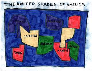
If you can't quite make it out, the purple states are Texas and Colorado, and while I have no idea where he thinks the "State of News" is, I can tell him that it isn't a place to be right now.
Though you can't tell from this map, the amount of beachfront property available in Kansas is very limited. And in Elijah's world, that coast-to-coast flight from "York" to "Caforina" sure seems a lot easier. No matter, Elijah was extremely proud of his map, and, during our trip, needed to know where it was on a daily basis.
Our little guy's career as a cartographer continued when we got home, but this time it was global in nature...

Naturally, Washington plays a major role in world affairs and can't be ignored, but its placement is telling. Florida has to be on there, because that's where Mickey Mouse lives, and besides, without Florida, what would be the purpose of spring break? Mexico is where Mom's favorite drink (magaritas) comes from. And Kansas proudly sits right there on top of the world.
After all, there's no place like home.


No comments:
Post a Comment